The Key to Accurate and Reliable Location Information
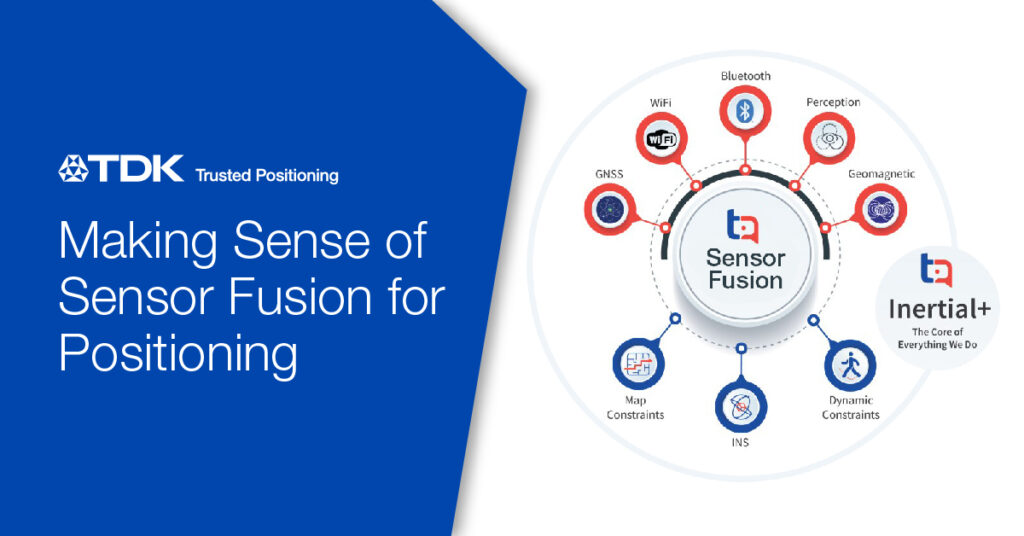
In today’s technology-driven world, accurate and reliable positioning information has become indispensable for numerous applications, ranging from navigation systems to augmented reality experiences. However, achieving pinpoint accuracy in location-based services is no easy feat, especially considering the diverse environments and conditions in which these systems operate. Relying on a single location technology falls short in providing consistent results across all scenarios. Enter sensor fusion, an innovative approach that combines the strengths of multiple sensors to overcome the limitations of individual technologies. This article will guide you through the concept of sensor fusion, explain the difference between absolute and relative positioning sensors, highlight the distinctions between indoor and outdoor environments, and introduce TDK Trusted Positioning’s solutions that leverage sensor fusion to deliver unrivaled positioning performance.
Sensor Fusion: Overcoming the Limitations of Individual Technologies
Achieving accurate and reliable positioning often requires the integration of multiple sensors, a technique known as sensor fusion. By combining the strengths of different sensors, sensor fusion compensates for the weaknesses and limitations of individual technologies. For instance, while GPS/GNSS receivers provide global positioning information, they can be affected by signal blockages in urban environments or dense foliage in outdoor settings. Inertial sensors, on the other hand, excel at providing continuous positioning updates but suffer from drift over time. By fusing the data from GPS/GNSS and inertial sensors, sensor fusion systems can obtain accurate and reliable positioning, mitigating the shortcomings of each technology. This fusion of sensor data enables robust and consistent performance across various outdoor environments and conditions.
Absolute vs. Relative Positioning Sensors: Understanding the Difference
When it comes to positioning, sensors can be broadly categorized into absolute and relative positioning sensors. Absolute positioning sensors, such as GPS/GNSS receivers, provide positioning information with respect to a global coordinate system. These sensors offer a high-level view of the user’s position but may struggle in environments where satellite signals are obstructed or weakened. On the other hand, relative positioning sensors, including inertial sensors and barometric pressure sensors, measure the changes in position and orientation relative to a starting point. These sensors excel at capturing precise movements but may suffer from drift or accumulated errors over time. By combining the outputs of absolute and relative positioning sensors through sensor fusion, a more accurate and robust positioning solution can be achieved.
Below is a list of commonly used sensors in positioning systems, categorized according to their positioning type. Some sensors may be both absolute or relative, depending on how they are referenced with respect to a coordinate frame.
| Absolute Positioning Sensors | Relative Positioning Sensors |
| GPS (Global Positioning System) | Inertial Measurement Units (IMUs) |
| GNSS (Global Navigation Satellite System) | Map Matching |
| Wi-Fi Access Point Systems | Visual Lane Tracking |
| Wi-Fi Fingerprint Systems | Ultrasonic Range Sensors |
| Cell Tower Triangulation | Barometric pressure (altitude) Sensors |
| Visual Light Communication (VLC) | |
| Ultra Wideband (UWB) | |
| Geomagnetic Fingerprint Systems | |
| BLE Fingerprint Systems | |
| BLE Proximity | |
| LiDAR/Camera/Radar Positioning from Maps |
Indoor vs. Outdoor Environments: Tailoring Sensor Fusion to Different Settings
The choice of sensors in a positioning system depends on the environment in which it operates. Indoor and outdoor environments present unique challenges and require different sensor configurations. In indoor settings, GPS signals are often weak or unavailable, necessitating the use of alternative technologies such as WiFi access points, Bluetooth beacons, and ultra-wideband (UWB) systems for positioning. In contrast, outdoor environments typically rely on GPS/GNSS receivers as a primary positioning technology. However, the availability of satellite signals can be compromised in urban areas or dense foliage. In these scenarios, sensor fusion systems that combine GPS/GNSS with other sensors, such as inertial sensors or perception sensors (LiDAR/Vision/Radar), can provide accurate and continuous positioning. By tailoring sensor fusion to the specific requirements of indoor and outdoor environments, reliable and robust positioning solutions can be achieved.
To illustrate the contrasting requirements, the following tables proposes some optimal uses of sensors for Indoor or Outdoor Positioning. Again, note that many of the sensors can be used both Indoors and Outdoors.
| Indoor Positioning Sensors | Outdoor Positioning Sensors |
| Wi-Fi Access Points | GPS/GNSS Receivers |
| Bluetooth Beacons | Cellular Networks (Cell Towers) |
| Ultra-Wideband (UWB) | LiDAR (Light Detection and Ranging) |
| RFID (Radio Frequency Identification) | Radar (Radio Detection and Ranging) |
| Ultrasonic | Inertial Measurement Units (IMUs) |
| Inertial Measurement Units (IMUs) | Barometric |
| Geomagnetic | Camera-Based Systems |
In the previous sections, we explored the concept of sensor fusion and its role in different environments as well as its role in overcoming the limitations of individual positioning technologies. Now, let’s delve into TDK Trusted Positioning’s solutions that harness the power of sensor fusion to deliver accurate and reliable positioning performance in various applications and environments.
FAQs: TDK Trusted Positioning Solutions
Q: What is the objective of TDK Trusted Positioning solutions?
A: Our objective is to accurate and reliable positioning solutions at a price feasible for large-scale implementation, regardless of the application or use case.
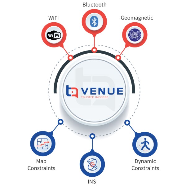
Q: How does VENUE work for indoor positioning?
A: VENUE creates an indoor positioning solution using a mobile device and an indoor fingerprint map. By leveraging built-in inertial and magnetic sensors, VENUE tracks the movement of a person or object within the mapped environment, providing accurate indoor positioning information without need for added infrastructure.
Q: Can TDK Trusted Positioning solutions be used for outdoor applications?
A: Absolutely! Our solutions are designed to adapt to different environments. For outdoor applications, we offer robust sensor fusion algorithms that integrate GPS/GNSS receivers, inertial sensors and low-cost perception sensors, such as imaging radar and cameras, to achieve accurate and reliable positioning.
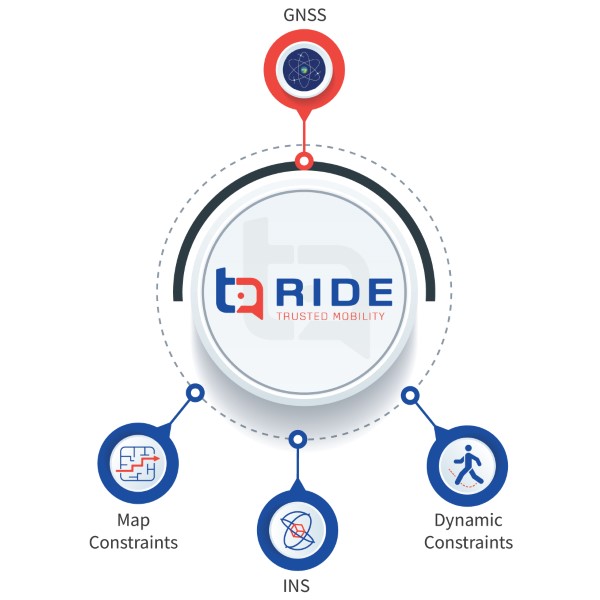
Q: How does RIDE work for 2-wheeled platforms?
A: RIDE obtains accurate positions, orientations, and rider dynamics of 2-wheeled platforms by integrating inertial sensors and GNSS sensors. Low-cost MEMS sensors such as accelerometers and gyroscopes are always-on and detect movement, driver dynamics, accurate drop-off position, and fall detection. When used with GNSS updates, these inertial sensors can filter GNSS multipath and save power. Our INS algorithms in RIDE are tuned and adapted for 2-wheel vehicle dynamics.
The cost constraints and low profitability of micro mobility applications limit the integration of perception sensors, but once costs reduce, we expect RIDE to integrate other outdoor positioning sensors.
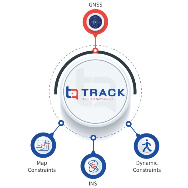
Q: How does TRACK provide enhanced vehicle positioning?
A: TRACK uses inertial MEMS sensors and GNSS to provide enhanced vehicle positioning in challenging environments. The accelerometers and gyroscopes in the inertial core continuously track the relative movement of the vehicle and use GNSS information as absolute updates when available. In areas where GNSS becomes unreliable, the inertial and map aids filter out erroneous data and provide reliable positioning without GNSS. Calibration and misalignment are automatically determined through typical driving motion. Inertial, road maps and GNSS sensors are accurate and reliable enough to maintain road level accuracy, which is the requirement for navigation applications.
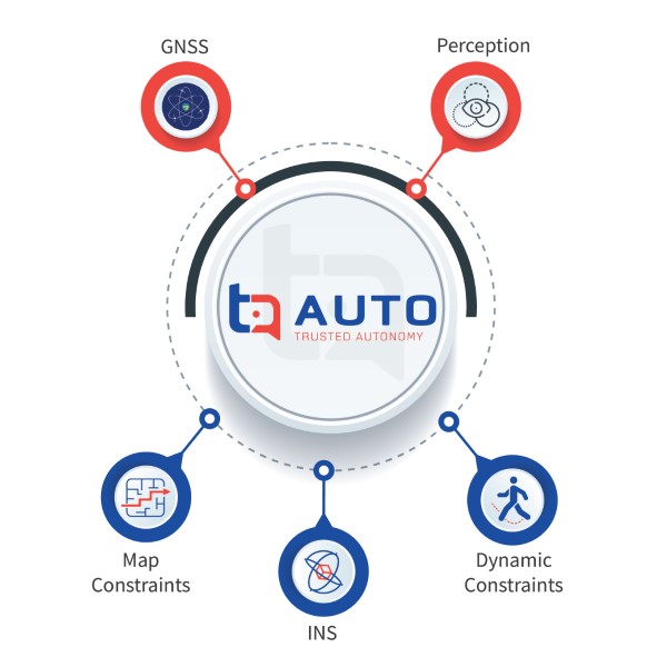
Q: How does AUTO enable high-accuracy positioning for autonomous wheeled platforms?
A: AUTO seeks to provide decimeter level accuracy for autonomous applications. AUTO achieves high accuracy, high integrity, and lower-cost positioning for autonomous wheeled platforms by integrating automotive-grade IMU’s, vehicle speed, high-accuracy GNSS, and perception sensors, all accurately timed to provide more accuracy than our TRACK product. The inertial navigation, combined with optional imaging radar and GNSS, enables decimeter-level positioning in challenging GNSS environments, including urban and residential areas. TDK Trusted Positioning’s world-class inertial navigation software has improved INS-only performance by a factor of ten times over previous generations to ensure accurate positioning with available perception sensors.
Q: What industries can benefit from TDK Trusted Positioning solutions?
A: TDK Trusted Positioning solutions have diverse applications across various industries, including transportation, logistics, robotics, industrial automation, and smart cities, among others. Our solutions cater to any scenario that requires accurate and reliable positioning information.
Q: How does TDK Trusted Positioning ensure accuracy and reliability?
A: TDK Trusted Positioning combines the power of sensor fusion with advanced algorithms and software to achieve accurate and reliable positioning. Our solutions integrate multiple sensors, such as inertial sensors, GNSS, and other wireless signals, to deliver robust and consistent performance in diverse environments.
Sensor fusion is the key to achieving accurate and reliable positioning in various applications and environments. By combining the strengths of multiple sensors, sensor fusion overcomes the limitations of individual technologies, enabling robust and consistent performance. TDK Trusted Positioning specializes in sensor fusion for land-based applications, catering to both indoor and outdoor positioning needs. Their solutions leverage innovative algorithms and software to integrate sensors such as GPS/GNSS, inertial sensors, cellular networks, and more, ensuring high-quality positioning performance for diverse industries. Whether it’s indoor positioning, outdoor tracking, or high-accuracy positioning for autonomous platforms, TDK Trusted Positioning’s solutions deliver the accuracy, reliability, and robustness required for today’s demanding positioning requirements.